Pacific Daylight Time
PDT(UTC-7)
- Los Angeles
- San Francisco
- Seattle
- San Diego
- Portland
Live clocks for 11 U.S. zones, plus a static map of the mainland time zones
AKDT(UTC-8)

HST(UTC-10)
HADT(UTC-9)
SST(UTC-11)
PDT(UTC-7)
MDT(UTC-6)
CDT(UTC-5)
EDT(UTC-4)
MST(UTC-7)
HST(UTC-10)

CHST(UTC+10)
Puerto Rico / US Virgin Islands
AST(UTC-4)
Arizona, Hawaii, American Samoa, Guam, Puerto Rico, and the U.S. Virgin Islands remain on Standard Time year-round.
Quick links to convert between mainland U.S. time zones. Opens each pair page (or the live time zone converter).
PDT(UTC-7)
MDT(UTC-6)
CDT(UTC-5)
EDT(UTC-4)
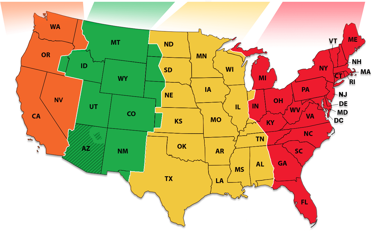
The United States spans four standard Time Zones—Eastern, Central, Mountain, and Pacific—each Time Zone is one hour apart from east to west. That means a three-hour gap between New York and Los Angeles on the same calendar day. Most of Alaska uses Alaska Time (UTC−9 / −8 with DST); the far western Aleutians (including Adak) use Hawaii–Aleutian Time (UTC−10 / −9 with DST). Hawaii (UTC−10, no DST) sits outside the four-mainland Time Zones. U.S. territories also use additional time zones, including Atlantic Standard Time (AST, UTC−4, no DST) in Puerto Rico and the U.S. Virgin Islands, Chamorro Time (UTC+10, no DST) in Guam and the Northern Mariana Islands, and Samoa Standard Time (UTC−11, no DST) in American Samoa. Those locations do not appear on a four-zone mainland map.
Arizona is the mainland exception. Most of the state, including Phoenix, Tucson, and Mesa, stays on Mountain Standard Time (UTC−7) year-round and does not observe daylight saving. Denver and most Mountain Time Zone cities spring forward to Mountain Daylight Time (MDT), while most of Arizona stays on Mountain Standard Time (MST) year-round. From the second Sunday in March through the first Sunday in November, Pacific Daylight Time and Arizona local time always match; from the first Sunday in November through the second Sunday in March, Arizona runs one hour ahead of Pacific Standard Time. Scheduling calls between California and Arizona requires checking the date, not assuming a fixed one-hour gap. See Arizona and DST for the full rule set.
Broadcast and travel listings commonly label times as “ET,” and some still say “EST,” even when Eastern Daylight Time applies. A 9:00 PM ET sports broadcast is 8:00 PM CT in Chicago and 6:00 PM PT in Seattle during daylight months; in winter the Pacific slot is 6:00 PM PST. Flight departure boards at hub airports show local time—a connection in Dallas (Central) after a red-eye from San Francisco can land at a different local time than the itinerary’s origin city suggests.
Indiana adds a smaller wrinkle: most counties use Eastern time, while a few northwest and southwest counties follow Central. Chicago (Central) and South Bend (Eastern) are always one hour apart. Nearby northwest Indiana counties such as those around Gary and Hammond stay on Central with Chicago, so the Time Zone can change when you cross a county line near the metro edge—not because South Bend itself switches.
Mountain Time itself splits in summer: Denver observes MDT (UTC−6) while Phoenix stays MST (UTC−7). A Pacific to Arizona MST conversion therefore depends on the season; Colorado summer clocks follow MDT, not this Arizona baseline. Network television prime-time slots advertised as “8/7 Central” show the Eastern–Central one-hour step but give no guidance for Mountain or Pacific viewers. Coast-to-coast pairs: PST to EST and EST to PST; overlap windows in East Coast vs West Coast meeting times. For three or more cities, use the World Meeting Planner.
There is no single national clock. In everyday use, the United States has four primary zones—Eastern, Central, Mountain, and Pacific—plus Alaska and Hawaii, and separate zones for populated oversea territories. How many you “count” depends on whether you include those extras and local exceptions such as Arizona.
This page shows 11 live zone clocks for the places most people need day to day:
| Shown on this page | Count | Zones |
|---|---|---|
| Mainland (with Arizona split out) | 5 | Eastern, Central, Mountain (DST areas), Arizona (no DST), Pacific |
| Alaska and Hawaii | 3 | Alaska, Aleutian (Adak), Hawaii |
| Populated territories | 3 | Atlantic (Puerto Rico / U.S. Virgin Islands), Chamorro (Guam / Northern Mariana Islands), Samoa (American Samoa) |
| Total live clocks | 11 | The clocks above this FAQ |
Other U.S. jurisdictions exist for technical or maritime use—for example Wake Island (UTC+12) and Baker / Howland Island (UTC−12)—but this page does not show live clocks for those uninhabited areas. The mainland graphic is a static map image of the four primary four Time Zones; it is not interactive and does not show county-level boundaries.
Most of the country observes Daylight Saving Time under the Energy Policy Act. Abbreviations use "D" in DST months (for example EDT or PDT) and "S" in standard time (for example EST or PST). Exceptions such as Arizona, Hawaii, and several territories are covered below.
Most of Arizona stays on Mountain Standard Time (UTC-7) year-round and does not spring forward. The main reason is practical: summers in Arizona are already extremely hot, and shifting clocks ahead would push daylight later into the evening, when temperatures are still high and cooling demand is at its peak. Arizona is allowed to sit out DST under the Uniform Time Act, as long as it remains on standard time.
One local exception: the Navajo Nation in northeastern Arizona does observe DST, so it stays in sync with Navajo lands in Utah and New Mexico. The Hopi Reservation, surrounded by Navajo land, stays on year-round MST like the rest of Arizona.
Indiana is not a single-offset state. Most counties—including Indianapolis, Fort Wayne, Bloomington, and South Bend—use Eastern Time (America/Indiana/Indianapolis and related IANA zones) and observe the same March / November DST change as New York. A minority of counties sit on Central Time: several in the northwest near Chicago (for example Lake, Porter, LaPorte, Newton, and Jasper) and a cluster in the southwest near Evansville (for example Gibson, Posey, Vanderburgh, Warrick, and Spencer). Those Central counties are commonly represented with IANA IDs such as America/Chicago, America/Indiana/Knox, or America/Indiana/Tell_City, depending on the locality.
The practical trap is treating “Indiana” as Eastern by default. A 9:00 a.m. meeting in Chicago (Central) is 10:00 a.m. in Indianapolis (Eastern) year-round under current rules, because both sides observe DST on the same calendar dates. The gap flips only when you compare an Indiana Eastern city with a place that does not change clocks—Arizona is the common mainland case—or when software maps a ZIP code to the wrong county zone.
Northwest Indiana cities such as Gary and Hammond follow Central so they stay aligned with the Chicago metro; South Bend, still in Indiana but on Eastern, is one hour ahead of Chicago. Southwest, Evansville is Central while Bloomington (Eastern) is one hour ahead. Calendar invites that say only “Indiana time” without a specific city could result a wrong local time. Prefer to name a city or convert with EST to CST / CST to EST.
Historically, Indiana’s zone map shifted several times in the twentieth century; the current Eastern-majority / Central-pocket layout has been stable for years under DOT boundary rules. County-level detail is beyond this page’s static mainland map—use a city clock or converter when the meeting is near a Time Zone line.
The populated U.S. oversea territories on this page use three fixed zones: Atlantic (Puerto Rico and the U.S. Virgin Islands, UTC-4), Chamorro (Guam and the Northern Mariana Islands, UTC+10), and Samoa (American Samoa, UTC-11). None of them observe mainland Daylight Saving Time, so their time stay the same year-round—while the gap versus New York or Los Angeles still changes when the mainland springs forward or falls back.
Puerto Rico and the U.S. Virgin Islands use Atlantic Standard Time (AST, UTC-4) via America/Puerto_Rico. In winter, AST matches Eastern Standard Time; from mid-March through early November, Eastern switches to EDT (UTC-4) while Puerto Rico stays on UTC-4, so San Juan and New York often show the same wall-clock hour during mainland daylight months. A recurring “9:00 a.m. ET” invite is usually fine for San Juan in summer, but in winter it is 10:00 a.m. in Puerto Rico unless the invite is tied to Atlantic time explicitly.
Guam and the Northern Mariana Islands use Chamorro Standard Time (ChST, UTC+10) via Pacific/Guam / Pacific/Saipan. For many workdays, they are already on the next calendar day compared to California: Monday afternoon on the West Coast is Tuesday morning on Guam. 9:00 a.m. on Monday on the US mainland (Pacific Time) lands in the early morning hours on Tuesday in Guam, while late Pacific evenings are more usable for Guam morning.
American Samoa uses Samoa Standard Time (SST, UTC-11) via Pacific/Pago_Pago. It is one hour behind Hawaii (HST, UTC-10) year-round. Calls between Pago Pago and Honolulu keep that fixed one-hour gap; calls to the mainland often span eleven hours or more, depending on the U.S. zone and whether DST is in effect.
Hawaii is a state, not a territory, but it shares the no-DST pattern (HST, UTC-10). Uninhabited outlying areas such as Wake Island or Baker Island have official offsets on this page’s overview table but no live clocks. For Hawaii–East Coast pairs see HST to EST; for mainland multi-city mixes use the World Meeting Planner with named cities rather than a single “U.S. time” label.
Across the United States, Eastern and Pacific are three hours apart year-round. Both coasts change clocks on the same federal DST dates, so the three-hour gap does change when DST starts or ends. When it is 9:00 a.m. in New York, it is 6:00 a.m. in Los Angeles or Seattle; when it is noon Pacific, it is 3:00 p.m. Eastern.
Central Time sits one hour behind Eastern and one hour ahead of Mountain; Mountain sits one hour behind Central and one hour ahead of Pacific (except Arizona in summer, when Phoenix stays on MST and often matches Pacific Daylight Time). A coast-to-coast roster that also includes Denver or Chicago needs those intermediate offsets, not only the three-hour New York–Los Angeles rule.
For meetings that need both coasts in typical office hours, a practical overlap is roughly 1:00 p.m. to 5:00 p.m. Eastern (10:00 a.m. to 2:00 p.m. Pacific). Earlier than that forces a pre-9:00 a.m. start on the West Coast; later than about 5:00 p.m. Eastern pushes Pacific staff past mid-afternoon and Eastern staff into early evening. All-hands at 9:00 a.m. Eastern are 6:00 a.m. Pacific—workable for some teams, harsh for others. All-hands at 9:00 a.m. Pacific are noon Eastern, which is easier eastbound but may collide with East Coast lunch.
Sample anchors (Eastern → Pacific): 12:00 p.m. ET = 9:00 a.m. PT; 2:00 p.m. ET = 11:00 a.m. PT; 4:00 p.m. ET = 1:00 p.m. PT. Anchorage is usually four hours behind New York year-round (both observe the same federal DST weekends). Hawaii does not observe DST, so it is about five hours behind Eastern in winter and six hours behind in summer. Add Alaska or Hawaii to a coast-to-coast call and the shared window shrinks—use a dated converter for a specific day.
Broadcast and sports listings often say “8/7c” (Eastern / Central) without stating Pacific; Pacific viewers subtract three hours from Eastern, not two. Flight and hotel confirmations use local airport or property time. You can convert with PST to EST or EST to PST, read East Coast vs West Coast meeting times, or plan three or more cities in the World Meeting Planner.
Below are the U.S. zones represented by the live clocks on this page, with common IANA identifiers and the areas they cover. These IDs are for reference; they are not labeled on the static map image.
Standard (EST): UTC-5 | Daylight (EDT): UTC-4
Covers much of the East Coast, including New York, Washington, D.C., Florida, Pennsylvania, Massachusetts, Georgia, and the eastern parts of Michigan, Kentucky, and Tennessee.
Standard (CST): UTC-6 | Daylight (CDT): UTC-5
Covers the Midwest and Gulf Coast, including Illinois, most of Texas (except the El Paso area), Minnesota, Iowa, Missouri, Oklahoma, Arkansas, Louisiana, and the western parts of Tennessee and Kentucky.
Standard (MST): UTC-7 | Daylight (MDT): UTC-6
Covers the Rockies, including Colorado, Utah, Montana, Wyoming, New Mexico, southern Idaho, and western North Dakota and South Dakota.
Year-round UTC-7 — Arizona does not observe daylight saving time.
Exception: the Navajo Nation in northeastern Arizona observes DST and shifts to UTC-6 in summer, so it stays aligned with Navajo lands in Utah and New Mexico. The Hopi Reservation, which sits inside Navajo land, stays on year-round UTC-7 like the rest of Arizona.
Standard (PST): UTC-8 | Daylight (PDT): UTC-7
Covers California, Washington, most of Oregon (except Malheur County), Nevada, and northern Idaho.
Standard (AKST): UTC-9 | Daylight (AKDT): UTC-8
Covers most of Alaska, including Anchorage, Fairbanks, and Juneau.
Hawaii (Pacific/Honolulu): HST (UTC-10) year-round — no DST.
Aleutian Islands (America/Adak): HAST (UTC-10) in winter and HADT (UTC-9) in summer.
Atlantic (America/Puerto_Rico), Chamorro (Pacific/Guam / Pacific/Saipan), and Samoa (Pacific/Pago_Pago). Offsets and mainland scheduling notes are in What Time Zones do U.S. territories use? above.
Time Zone boundaries in the United States are set by the U.S. Department of Transportation (DOT), not by astronomy agencies. Standard time zones date back to November 18, 1883, when the railroads adopted them to make train schedules safer and more consistent. Changes today are handled under Title 15 of the U.S. Code.
The clocks and zone labels on this page follow the IANA Time Zone Database (for example America/New_York, America/Chicago, America/Denver, America/Los_Angeles, America/Phoenix, Pacific/Honolulu). Most countries observe Daylight Saving Time; Arizona, Hawaii, and several territories stay on standard time year-round. For a broader overview, see Time in the United States (opens in new tab).
Time data: IANA / TZDB Last verified: July 21, 2026 About Contact